


Caldor Fire has scorched 277 square miles, just 14 percent contained
South Lake Tahoe, Calif./Nev. – Cal-Fire has posted Evacuation orders and routes for South Lake Tahoe as the Caldor Fire continues to rage in El Dorado County.
The Caldor Fire began on August 14 and is currently Northern California’s second largest blaze at 177,000 acres. The Dixie Fire has consumed over 777,183 acres and the Monument Fire, 164,000 acres.
⤥ Summer Fun Starts Here ⤦

⤥ Summer Fun Starts Here ⤦
⤥ Summer Fun Starts Here ⤦

⤥ Summer Fun Starts Here ⤦
To date, the three largest fires in California have charred over 1,590 square miles, a combined area larger than the state of Delaware. Conditions in South Lake Tahoe remain warm and dry.
Evacuation Map (Clickable)
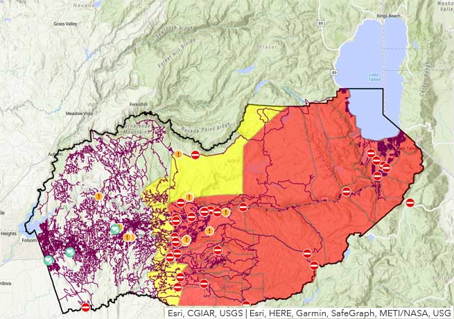
- (Click on Map for more info)
Update to Evacuation Orders (August 30, 11:40 a.m.)
WHEN: Effective Immediately
WHERE: El Dorado County
Evacuation Order:
El Dorado County
Heavenly
• East of Pioneer Trail between Larch and Al Tahoe, to include the area of Heavenly Ski Resort out to the Alpine County Line and the Nevada State line on the East.
Stateline
• East of Ski run on the lake side of Pioneer Trail and also both sides of Pioneer Trail between Larch and the Nevada State line.
Evacuation Routes:
• Evacuate Eastbound on Highway 50 towards Nevada.
Evacuation Shelters:
• Truckee Veterans Hall 10214 High Street, Truckee, CA 96161
• Douglas County Community Center, 1329 Waterloo Lane, Gardnerville, NV
NOTES:
View online evacuation map.
Update to Evacuation Orders (August 30, 10:55 a.m.)
WHEN: Effective Immediately
WHERE: El Dorado County
Evacuation Order:
El Dorado County
Tahoe Keys
• All residences with the Tahoe Keys community and all residents accessed from the streets connected to Tahoe Keys Blvd, staying east of 3rd Street.
Tahoe Island
• East of Highway 50/ Highway 89 at the at the Lake Tahoe Blvd and Highway 89 Highway 50 intersection. This includes the area of Barton Hospital and the area of Winnemucca to the “Y”. Also north of Highway 50 west of Tahoe Keys Blvd following along the north side of Highway 89 through the end of town prior to Pope Beach.
Al Tahoe
• All residences off of Lakeview which is west of Highway 50 North of Blue Lakes Road and east of Tahoe Keys Neighborhood. Sierra Tract
• All residences on both sides of Highway 50 for the streets connected to O’Malley, Lodi, Silver Dollar and Rubicon Trail.
Bijou
• The residences between Al Tahoe on the east side of Johnson Blvd to include the streets of Treehaven and Fremont and extending to the east in to all residences west of Ski Run and east of Pioneer Trail.
Evacuation Routes:
• Evacuate Eastbound on Highway 50 towards Nevada.
Evacuation Shelters:
• Truckee Veterans Hall 10214 High Street, Truckee, CA 96161
• Douglas County Community Center, 1329 Waterloo Lane, Gardnerville, NV
All previous evacuation orders and warnings remain in effect.
A mandatory evacuation order is defined as an immediate threat to life. This is a lawful order to leave now. The area is lawfully closed to public access.
An evacuation warning is defined as a potential threat to life and/or property. Those who require additional time to evacuate and those with pets and livestock should leave now.
CURRENT SITUATION:
Humidity recovery remained poor overnight and allowed the fire to continue to actively burn. Fuel conditions remain critical and we still see active crown runs and group torching in the northeastern divisions of the fire. Current fire behavior is contributing to ember casts traveling up to half a mile. We anticipate early morning winds in the northeast area of the fire. Fire weakened trees continue to present a risk for crews.
To better provide public and firefighter safety due to extreme fire conditions throughout Northern California, and strained firefighter resources throughout the Country, the USDA Forest Service Pacific Southwest Region is announcing a temporary closure of nine National Forests. This closure will be effective on August 22, 2021, at 11:59 p.m. through September 6, 2021, at 11:59 p.m.
Local Assistance Center:
Address: 6699 Campus Drive, Placerville, CA 95667. Located at Folsom Lake Community College, El Dorado Campus, Fitness Center Building.
Hours: Monday through Friday 10:00 a.m. to 5:00 p.m., Wednesdays 1:00 p.m. to 7:00 p.m.
(21+ years strong)
Welcome to the brighter side!
Get in front of local customers! 24/7 (365)


