Property destruction and evacuation orders
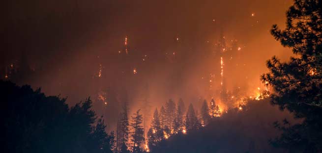
Auburn, Calif. -Placer County has proclaimed a local emergency due to the ongoing threat from the River Fire.
The fire in Placer and Nevada counties has burned 2,600 acres, damaged or destroyed an estimated 108 structures and 2,400 Colfax-area residents remain under evacuation orders.
A local emergency proclamation asserts continuing risk to life and property and that the response is beyond the capabilities of local resources. Placer’s proclamation requests state and federal assistance, but a federal disaster has not yet been declared that would authorize individual disaster assistance for residents and businesses.
“We are tremendously grateful to our public safety partners for so capably attacking this fire and protecting our residents,” said Placer County Emergency Services Director and County Executive Officer Todd Leopold. “We’re fully committed to doing everything we can to support our residents who’ve been so deeply affected by this disaster and this proclamation is a key step in making sure we’ve got access to all available resources that can help.”
California Governor Gavin Newsom has also proclaimed a state of emergency in Placer County, and the Federal Emergency Management Agency has awarded a fire management assistance grant to ensure the availability of resources to suppress the River Fire.
The River Fire impacting in Placer and Nevada counties is currently 30 percent contained according to Cal Fire.
ire crews made good progress working throughout the night to strengthen control lines and continue defending structures within the interior of the burn. Tree falling modules will continue to remove hazard trees within the burn area throughout today’s operational period. Additionally tactical patrol around the perimeter of the fire line to mopup hot spots is a priority for crews assigned to the River Fire.
CAL FIRE damage assessment teams are working with the building department and environmental health to collect data on structure and infrastructure damages.

Evacuation Orders:
- Refer to PCSO Evacuation Map for Placer County
- Refer to Ready Nevada County Evacuation Map for Nevada County
Placer County:
- Zone 1 : Evacuation Order-Railroad tracks west to the river. Mt. Howell Rd north to
Ben Taylor Rd. - Zone 2 : Evacuation Order-Rollins Lake Rd west to the river. Ben Taylor Rd north to
Rollins Lake. - Zone 3 : Evacuation Order-City of Colfax, west of I 80
Nevada County:
- NCO-E050: Dog Bar Rd. (Central); Mount Olive Rd.(Western)-North of Buck Ridge Rd.; Dog Bar Rd. and East; South of Rattlesnake and Birch Meadow Acres; West of Clydesdale Rd.
- NCO-E102: Sierra Knoll Estates; Dog Bar (South) – North of Retherford Rd.; Sierra Knoll Estates and East; South of Taylor Crossing Rd.; West of the Bear River (County Line)
- NCO-E103: Mount Olive (Eastern)-North and South Mt. Olive Rd., West of Hwy 174, North of Bear River, East of Mt Olive Including Rolphholm Rd. and Clydesdale Rd.
- NCO-E178: Sunshine Valley Rd., Old Coach Way- All of and North of Old Coach Way, East of Woodpecker Ravine, South and West of Lower Colfax Rd.
- NCO-E180: Orchard Springs & Bear River Pines-South of Greenhorn Access Rd., West of Rollins Lake, North of the Bear River, East of Hwy 174.
- NCO-E386: Powerline Rd., Talking Pines Rd., Panorama Dr.-The east side of Colfax Hwy south of Bertino Rd. The west side of Lower Colfax Rd. south of Panorama Dr., North of the Chicago Park Post Office.
Evacuation Warnings:
Placer County:
- Zone 4: Railroad tracks west to the river, west Weimar Cross Rd. north to Dogbar Rd.
- Zone 5: East of I 80 to Rollins Lake, north to Secret Town
Nevada County:
- NCO-E048: Alta Sierra Country Club; Brewer Rd. (Northern); Fay Rd., Carrie Dr., Rainbow Rd. – North of Wolf Creek; Annie Drive and West; South Alta Sierra Dr.;
West of Dog Bar and Norvin Way - NCO-E163: Brewer Rd. (Southern); Buck Mountain; Lodestar Dr.- North of Conestoga Dr.; Brewer Rd. and East; South of Clover Valley & Norvin Way; West of Dog Bar Rd.
- NCO-E179: Peardale, (Central) Lower Colfax, Dalmatian- South and West of Hwy 174, North of Sunshine Valley and Panorama Dr., East of Woodpecker Ravine
- NCO-E181: Sontag; You Bet Rd. (Western); Greenhorn Access Rd.; Lost Lake Rd. (Southern)-East of Hwy 174, North and South of You Bet Rd., West of Greenhorn
Creek and North of Greenhorn Access Rd. - NCO-E187: You Bet Rd. (Eastern and Southern)-South of You Bet Rd., West of Steep Hollow Creek, North of Bear River and Rollins Reservoir, East of Little Green Horn Creek.
- NCO-E192: Woodpecker Ravine,Casa Loma Dr., Southern Rattlesnake Rd., Goodall Mine Rd.-South of Highland Dr., West of Woodpecker Ravine, North of Oak
Meadows, East of Rattlesnake Rd.
Evacuation Centers:
Placer County: Regional Park Gymnasium, 3770 Richardson Dr, Auburn
Nevada County: Bear River High School, 11130 Magnolia Rd, Grass Valley
Road Closures:
- Refer to PCSO Evacuation Map for Placer County
- Refer to Ready Nevada County Evacuation Map for Nevada County
Animal Evacuation Centers
Placer County: Placer County Animal Services Center: 11232 B Avenue Auburn, CA 95603
Nevada County: Nevada County Fairgrounds (animals only), 11228 McCourtney Rd, Grass Valley, CA 95949 is an animal shelter
(21+ years strong)
Welcome to the brighter side!
Get in front of local customers! 24/7 (365)


